You can display a street map for any individual listing. The listing
is plotted on a map next to existing schools, hospitals, and other points
of interest. (Additional street map functions are available for Mapping
Listing Search Results.)
A marker flags the location of the listing on the map.
The color of the marker indicates the listing status (e.g., available,
sold). See the legend below the map. Details display at the right side
of the page. You can click on the listing marker to return to the listing
report.
Adjust the view of the street map using the zoom buttons; see below.
NOTE: Certain listings cannot be geocoded, and therefore will not display
on the street map. If any of the following fields are incorrect or missing:
address,municipality, province,
postal code; or the street name or number doesn't exist in the database
(it may be a new house on an old street or a brand new street) the listing
may not display on the map. The MLS# is displayed at the right under the
heading "Could not be located". Click on any MLS# in this list
to display the listing detail view; click on the MLS# at the detail view
to display the listing.
The legend below the map defines the most common map markers. Click
Full Legend to display a comprehensive list of markers and other map information.
You can opt to perform a Radius Search from the centre-point of the
displayed map. Alternatively, you can save the Street Map for use in a
subsequent Radius Search. You can only save one map at a time. When you
opt to save a map any previously saved map is overwritten.
The white (lightened) button indicates the current
zoom setting. The mapping system uses three maps, of varying detail, and
applies three zoom levels at each map. The map zoom control includes nine
buttons; three for each of the three levels of detail:
Zoom Levels
Map Used
Map Details
.8 km, 1.6 km, 3 km
1:25,000 ratio map
The most detailed; shows all roads, side streets, legend markers. Most
maps in the MapArt book display at this ratio level.
6 km, 12 km, 25 km
1:250,000 ratio map
Shows major roads with fewer side streets and legend markers.
50 km, 100 km, 200 km
1:750,000 ratio map
Shows municipalities, areas, and highways.
You can also use the direction buttons (labeled
North, East, South, West) to adjust the map view. Click on a direction
button to shift the map in the chosen direction.
Select a Class
and Availability and then click
Submit.
TMLS displays the Radius Search page, with the
centre-point of the search pre-filled from the previous map.
Adjust the zoom level and fine-tune the centre-point,
if required. Enter search criteria, as needed, and select a radius or
draw a search area. See Radius Searches
for more information.
Below the Street Map viewer, click Save
this Location. (See Radius Searches
for using a saved map).
Tip:
You can print documents without extraneous reference information at the
top (header) and the bottom (footer) of each page. (See Special
Printing Format.)
 flags the location of the listing on the map.
The color of the marker indicates the listing status (e.g., available,
sold). See the legend below the map. Details display at the right side
of the page. You can click on the listing marker to return to the listing
report.
flags the location of the listing on the map.
The color of the marker indicates the listing status (e.g., available,
sold). See the legend below the map. Details display at the right side
of the page. You can click on the listing marker to return to the listing
report. 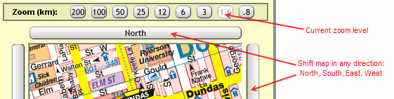
 to close the browser window and return to the
map.
to close the browser window and return to the
map.